geospatial

Threat Level Red

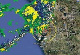
Integrating weather and GIS data for more accurate threat assessments.

Weather and GIS are being combined in new ways to provide better storm threat assessments - helping utilities create increasingly effective battle plans to defend against approaching storms.

Modernization Foundation

Near-term vision for advanced distribution management.

Recent superstorms and other major events have raised the bar for utility reliability and grid planning. By bringing together various advanced systems in an integrated distribution management platform, utilities can make power systems more resilient – and provide better service for customers.